The latest forecast has Dorian turning north before hitting Florida. But uncertainties remain.
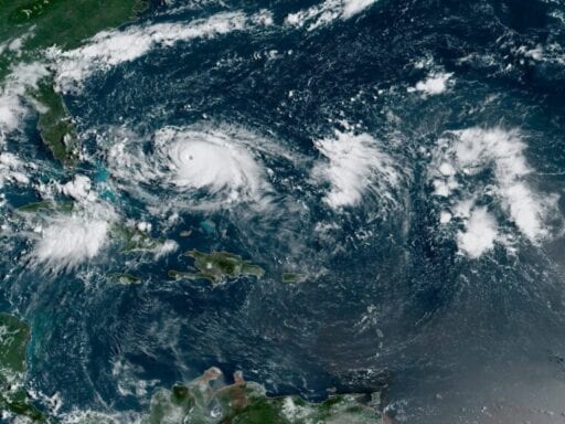
Hurricane Dorian slammed into the Abacos Islands in the Bahamas as an incredibly powerful Category 5 hurricane, with howling winds in excess of 185 mph and with gusts up to 220 mph. The storm brought with it a surge — aka coastal flooding — of 18-to-23 feet above normal tide.
Dorian is estimated to be the second most powerful hurricane ever recorded in the Atlantic Ocean, and ties the record for the most powerful storm to make landfall, according to the National Weather Service. Preliminary reports from the Abacos Islands show extreme devastation.
The storm is now heading toward Grand Bahama Island.
“A prolonged period of catastrophic winds and storm surge will affect the Abaco Islands and Grand Bahama Island tonight,” the National Hurricane Center (NHC) warned. “Everyone there should take immediate shelter and not venture into the eye.”
The storm currently is sustaining 185 mph winds, which make it an extremely dangerous Category 5 “major” hurricane. (Major hurricanes are Category 3 and higher.) Winds of that intensity have the power to strip houses of their roofs, uproot trees, and destroy structures entirely.
/cdn.vox-cdn.com/uploads/chorus_asset/file/7238885/scale.png) Zachary Crockett/Vox
Zachary Crockett/VoxAfter it passes through the Bahamas, the storm’s track grows more uncertain. The storm is not currently expected to make landfall in Florida, but instead, to stay about 20 miles offshore, sparing Florida the worst. However, the NHC warns that even small changes to the forecast can bring intensely dangerous conditions to the coast.
“Life-threatening storm surge and dangerous hurricane-force winds are possible along portions of the Florida east coast through mid-week, as only a slight deviation to the left of the official forecast would bring the core of Dorian near or over the coast,” the NHC advises. “Residents should listen to advice given by local emergency officials.”
Dorian remaining off the coasts would still present a dangerous situation. Dorian’s hurricane-force winds extend 45 miles outward from its eye, bringing with them rough surf, coastal flooding, high winds, and rain.
Again, it’s still possible Dorian could make landfall. So pay attention to reports. To prepare, some counties along the Florida coast have issued, or may issue, evacuation orders for certain residents. You can see all of those orders here.
Here’s the latest forecast map from the NHC. As you can see, it’s possible that Dorian will also impact Georgia and the Carolinas before heading farther up the coast.
Tropical storm-force winds might reach Florida by early Monday.
/cdn.vox-cdn.com/uploads/chorus_asset/file/19158744/155815_earliest_reasonable_toa_no_wsp_34.png) NOAA
NOAABut the risks of a major hurricane extend well beyond the wind. The storm could bring several inches of rain or more for parts of Florida and the Southeast. Here’s the latest rain forecast:
/cdn.vox-cdn.com/uploads/chorus_asset/file/19158748/155815WPCQPF_sm.gif)
Plus, the deadliest aspect of a hurricane tends to be storm surge (flooding caused by seawater pushed onshore by the hurricane’s winds). Right now, the NHC is forecasting four-to-seven feet of storm surge along the Florida coast. Specifically:
Volusia/Brevard County Line to Jupiter Inlet FL…4 to 7 ft
North of Deerfield Beach to Jupiter Inlet FL…2 to 4 ft
“The surge will be accompanied by large and destructive waves,” the NHC warns. “Surge-related flooding depends on the how close the center of Dorian comes to the Florida east coast, and can vary greatly over short distances.”
To prepare for all these threats, Florida Gov. Ron DeSantis has declared a state of emergency, freeing up resources to prep for the storm.
And here are the key messages the National Hurricane Center wants the public to know:
1. A prolonged period of catastrophic winds and storm surge will affect the Abaco Islands and Grand Bahama Island tonight. Everyone there should take immediate shelter and not venture into the eye.
2. Life-threatening storm surge and dangerous hurricane-force winds are expected along portions of the Florida east coast through mid-week, and storm surge and hurricane warnings are in effect. Only a slight deviation to the left of the official forecast would bring the core of Dorian near or over the Florida east coast. Residents should listen to advice given by local emergency officials.
3. There is an increasing likelihood of strong winds and dangerous storm surge along the coasts of Georgia, South Carolina, North Carolina later this week. Residents in these areas should continue to monitor the progress of Dorian and listen to advice given by local emergency officials.
4. Heavy rains, capable of producing life-threatening flash floods, are expected over northern portions of the Bahamas and coastal sections of the southeast and lower mid-Atlantic regions of the United States through late this week.
Remember: Forecasts can change. The good news is there’s still a lot of time to prepare.
How to follow Dorian:
- The National Hurricane Center has a page updating every few hours with the latest watches and warnings for Dorian. Check it out.
- Follow the National Hurricane Center on Twitter.
- Follow the Capital Weather Gang’s Twitter account. These folks tend to live-tweet storm updates.
- Here’s a Twitter list of weather experts, who will give you up-to-the-second forecasts and warnings.
Author: Brian Resnick
Read More