A worst-case scenario is playing out the Bahamas. Florida and the Southeast US may be spared the worst. But uncertainties remain.
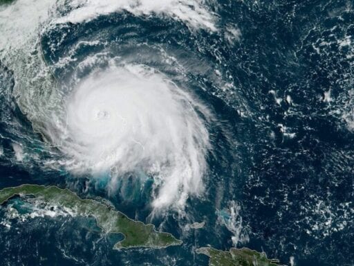
On Monday, Hurricane Dorian slammed into the Abacos Islands in the Bahamas as an incredibly powerful Category 5 hurricane, with howling winds in excess of 185 mph and with gusts up to 220 mph. The storm brought with it a surge — coastal flooding — of 18-to-23 feet above normal tide.
Dorian is estimated to be the second-most powerful hurricane ever recorded in the Atlantic Ocean, and ties the record for the most powerful storm to make landfall, according to the National Weather Service. Preliminary reports from the Abacos Islands show extreme devastation.
The storm weakened slightly and was (very slowly) moving through Grand Bahama Island on Monday, with winds gusting over 200 mph and 18 to 23 feet of coastal flooding. Plus, the forward motion of the storm nearly stalled, moving west at just 1 mph. The slower a storm moves, the more time it has to destroy communities in its path. It’s a worst-case scenario for a hurricane.
Dorian ravaging Grand Bahama over the last 14 hours.
Essentially the worst case scenario for the island. pic.twitter.com/UYxddpfxOA
— Dakota Smith (@weatherdak) September 2, 2019
Remarkably, the storm still hasn’t cleared the Bahamas.
“Devastating winds and [10-to-15 feet of] storm surge will continue to affect Grand Bahama Island for several more hours,” the National Hurricane Center reports. “Everyone there should remain in shelter.” The NHC also warns of “extreme flooding” due to a possible 30 inches of rain that have fallen.
Since making landfall on Grand Bahama Island 24 hours ago, #HurricaneDorian has only traveled about 40 miles. The eye of #Hurricane #Dorian remains parked near the north edge of the island. pic.twitter.com/yxxRu0Fx9u
— Philip Klotzbach (@philklotzbach) September 3, 2019
As of Tuesday morning, the storm had weakened a bit, sustaining 120 mph winds, making it an dangerous Category 3 “major” hurricane. (Major hurricanes are Category 3 and higher.) Winds near that intensity have the power to destroy homes. It’s a dangerous situation.
/cdn.vox-cdn.com/uploads/chorus_asset/file/7238885/scale.png) Zachary Crockett/Vox
Zachary Crockett/VoxThe storm is not currently expected to make landfall in Florida, but instead, to stay uncomfortably close offshore.
“The hurricane will then move dangerously close to the Florida east coast late today through Wednesday evening, very near the Georgia and South Carolina coasts Wednesday night and Thursday, and near or over the North Carolina coast late Thursday,” the NHC reports.
However, the NHC warns that even small changes to the forecast can bring intensely dangerous conditions to the coast. ”A relatively small deviation to the left of this track could bring the core of the hurricane near or over the coastline,” the NHC reports.
Right now, almost all of Florida’s Atlantic coast is under a hurricane warning or a tropical storm warning, meaning hurricane and tropical storm conditions are imminent. All of the Georgia coast in under a hurricane watch or tropical storm warning. Most of South Carolina’s coast is under a hurricane watch as well.
“Life-threatening storm surge and dangerous hurricane-force winds are expected along portions of the Florida east coast and Georgia coast, regardless of the exact track of Dorian’s center, ” the NHC advises. “Residents should listen to advice given by local emergency officials.”
Dorian remaining off the coasts would still present a dangerous situation. Dorian’s hurricane-force winds extend 45 miles outward from its eye, bringing with them rough surf, coastal flooding, high winds, and rain. Tropical storm-force winds extend 160 miles from the center.
Again, it’s possible Dorian could make landfall on the US East Coast. So pay attention to reports. To prepare, some counties along the Florida coast have issued evacuation orders for certain residents. You can see all of those orders here. Georgia Gov. Brian Kemp has ordered evacuations for six coastal counties. And evacuations have also been ordered in South Carolina as well.
Here’s the latest forecast map from the NHC. As you can see, Dorian may impact Georgia and the Carolinas as a major hurricane before heading farther up the coast.
But the risks of a major hurricane extend well beyond the wind. The storm could bring several inches of rain or more for parts of Florida and the Southeast. Here’s the latest rain forecast:
/cdn.vox-cdn.com/uploads/chorus_asset/file/19163393/093608WPCQPF_sm.gif) NOAA
NOAAThe deadliest aspect of a hurricane tends to be storm surge (flooding caused by seawater pushed onshore by the hurricane’s winds). Right now, the NHC is forecasting four-to-seven feet of storm surge along the Florida coast. Specifically:
Here’s is the 5 pm @NHC_Surge forecast for #Dorian: Water could reach these heights above ground if peak surge occurs at the time of high tide:
Storm Surge Warning extended N to Altamaha Sound Georgia. Storm Surge Watch extended N to South Santee River South Carolina. pic.twitter.com/QA6pN58Tji
— National Hurricane Center (@NHC_Atlantic) September 2, 2019
“The surge will be accompanied by large and destructive waves,” the NHC warns. “Surge-related flooding depends on the how close the center of Dorian comes to the Florida east coast, and can vary greatly over short distances.”
Here are the key messages the National Hurricane Center wants the public to know:
1. Devastating winds and storm surge will continue to affect Grand Bahama Island for several more hours. Everyone there should remain in shelter.
2. Life-threatening storm surge and dangerous hurricane-force winds are expected along portions of the Florida east coast and the coasts of Georgia and South Carolina, regardless of the exact track of Dorian’s center. Water levels could begin to rise well in advance of the arrival of strong winds. Residents in these areas should follow advice given by local emergency officials.
3. The risk of life-threatening storm surge and hurricane-force winds continues to increase along the coast of North Carolina. Residents in these areas should follow advice given by local emergency officials.
4. The flash flood threat will increase today and tonight along the Florida peninsula, then spread up the southeast and mid-Atlantic coast during the middle and latter part of the week.
Remember: Forecasts can change. But for many communities, there’s still time to prepare.
How to follow Dorian:
- The National Hurricane Center has a page updating every few hours with the latest watches and warnings for Dorian. Check it out.
- Follow the National Hurricane Center on Twitter.
- Follow the Capital Weather Gang’s Twitter account. These folks tend to live-tweet storm updates.
- Here’s a Twitter list of weather experts, who will give you up-to-the-second forecasts and warnings.
Author: Brian Resnick
Read More