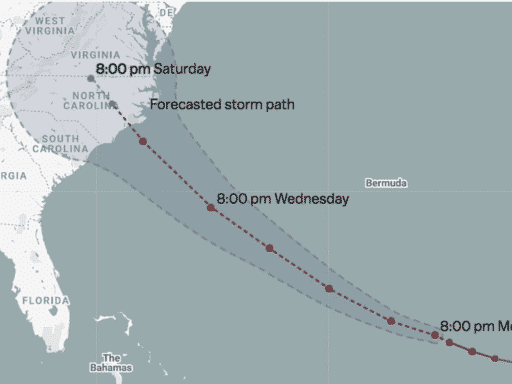
This map charts the course the storm has taken so far and shows NOAA’s best forecast for where it’s heading.
Hurricane Florence is heading to the Carolinas, and is expected to bring life-threatening storm surge and coastal flooding, punishing rains, and high winds. The storm is forecasted to make landfall Thursday or very early Friday morning, and already, communities along the coast are evacuating in preparation. The most dangerous aspect of a hurricane is often the storm surge, which is expected to top 6 or 9 feet in some areas. (View a storm surge warning risk map for the Carolinas, here).
Luckily, there’s still time to prepare. This map below charts the course the storm has taken so far and NOAA’s National Hurricane Center’s best available forecast for where it’s heading. The map will update automatically when new forecasts are published. Currently, the biggest question is not if the storm will hit the coast, but precisely where, and how intense will it be. Florence is expected to stay a category 4 or 5 storm over the next day and a half. And regardless of its exact rating, it will remain a dangerous situation.
Map by Ryan Mark and Casey Miller
How to follow Hurricane Florence:
- The National Hurricane Center has a page updating every few hours with the latest watches and warnings for Florence. Check it out.
- Follow the National Hurricane Center on Twitter; it will keep you up to date with all the latest forecasts, hazards, and warnings. Also follow its Charleston, South Carolina, branch.
- Follow the Capital Weather Gang’s Twitter account. These folks tend to live-tweet storm updates.
- Here’s a Twitter list of weather experts via meteorologist Eric Holthaus. These experts will give you up-to-the-second forecasts and warnings.
Author: Brian Resnick