Subtropical Storm Theta is now the 29th named storm of the season.
2020 has broken yet another extreme weather record: the most named tropical storms ever in an Atlantic hurricane season.
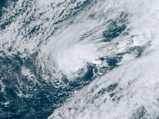
Early Tuesday morning, Subtropical Storm Theta formed in the middle of the Atlantic Ocean, according to the National Hurricane Center, making it the 29th named storm — a weather system strong enough to warrant an official designation — of the season. This beats the previous benchmark of 28 storms set in 2005. And before 2005, the most active hurricane season was in 1933, with 20 named storms.
[BREAKING] Overnight, the 2020 Atlantic Hurricane Season has broken an all time record. Subtropical Storm #Theta has formed in the Central Atlantic making it the 29th named storm of the season. This breaks the old record set in 2005 with 28 named storms. Up next, Iota? pic.twitter.com/m18P20aPfd
— NWS Weather Prediction Center (@NWSWPC) November 10, 2020
Theta is currently projected to move eastward, away from the United States. But a prior storm, Eta, is still churning in the Gulf of Mexico and may hit Florida this week as a tropical storm.
These recent storms highlight just how busy the Atlantic has been this year. Of the 29 storm systems, 12 reached hurricane strength and five reached Category 3 strength or higher, with winds topping 111 mph. In the United States, 12 storms made landfall and six did so at hurricane strength. There were so many storms this year that meteorologists ran through their entire list of official names and are now naming storms after letters of the Greek alphabet.
The record-breaking storm season comes amid a year of searing heat and unprecedented wildfires, with its damage toll worsened by human factors like building in harm’s way and climate change.
Unusual weather, oceanic cycles, and climate change contributed to 2020’s record-setting Atlantic hurricane season
There were some early warning signs that 2020 would be a standout year. The National Oceanic and Atmospheric Administration anticipated back in May that the Atlantic hurricane season would be above average. But in August, they had to upgrade their forecast from between 13 to 19 named storms to between 19 and 25, and that forecast still fell short.
One key factor this year was that the Atlantic Ocean was particularly warm. Surface water needs to be at least 26°C, or 79°F, to form a hurricane, so hotter water led forecasters to conclude that more energy would be available to form storms.
Air temperatures were also warmer this year, and 2020 is currently on track to be the warmest year on record. Air can hold on to about 7 percent more water for every degree Celsius it warms up, so warmer air means more moisture is available to fuel storms.
Another variable was the phase of El Niño—Southern Oscillation, or ENSO, a periodic warming and cooling pattern in the Pacific Ocean. The ENSO pattern this year led to calmer air over the Atlantic, which allowed tropical storms to more easily form. The Atlantic Ocean also goes through a multi-decade warming and cooling pattern. The ocean is currently in its warm phase, which is linked to higher hurricane activity.
/cdn.vox-cdn.com/uploads/chorus_asset/file/22026536/Nov_10_2020_11_15_43.gif) NOAA
NOAAOver the long term, humans are increasing the risks from these storms. There continues to be a lot of development in coastal areas vulnerable to tropical storms, increasing the damage tolls from the flooding and winds caused by the storms that do occur.
Humanity is also changing the climate. There is a lot of variability in hurricane patterns, making it tough to figure out which factors are the most significant in shaping trends. But scientists say that as average temperatures rise, the raw ingredients for tropical storms and hurricanes amplify. Warmer water, warmer air, and higher sea levels exacerbate the damage from tropical storms, though they may not necessarily affect the frequency of these events.
Subtropical Storm #Theta has formed in the Atlantic breaking the season record for the most named storms, previously held by 2005#Theta is the 29th named storm of the season & there is a 70% chance that a 30th will form in the next 5 days
See https://t.co/nr1pQlRTJx pic.twitter.com/d31rgZoz7T
— World Meteorological Organization (@WMO) November 10, 2020
“As the climate warms, we expect that the upper bound of how intense a hurricane can get … goes up at a certain rate with warming, and that’s been known for 33 years,” Kerry Emanuel, a professor of atmospheric science at the Massachusetts Institute of Technology told Vox in August. “More recently it’s also been understood that there is a cap on the rate of intensification, and that goes up faster.”
Emanuel noted that other human factors, like a reduction in sulfur air pollution since the 1980s, is also affecting the formation of tropical storms in the Atlantic.
Together, these factors aligned to create a record-breaking year. And more storms may still lie ahead this season, which officially ends on November 30.
Author: Umair Irfan
Read More